Mourning & Memory in the Age of Topocide
Thesis project, 2020
We live in the age of the mountain removers, the river rerouters, the forest erasers. Landscapes are routinely destroyed or changed irrevocably by development. Sometimes these changes are cataclysmic, and sometimes insidious. The losses that accompany them are unprecedented in their speed, depth, and breadth. To process and adapt to these changes, human beings must conceive new personal and collective rituals of grieving and memory.
In the age of topocide, protest and resistance are intertwined with the loss and grieving of landscape. When the destruction is committed by industry or the state, these losses are legitimized as productive use for the common good. Land protectors are criminalized and those who grieve are isolated. The result is a kind of disenfranchised grief that is at once personal, collective, and political.
Site C is located on the Peace river in northeastern British Columbia. The Peace River Valley, slated to be flooded when Site C is complete, is the last stretch in BC that has not been drowned in a reservoir.
The valley is Treaty 8 territory and the homeland of the Sikanni, Slavey, Dunne-za, Cree, and Salteau nations. The BC First Nations located on this side of the Rockies are inundated with extractive development, mostly forestry and fracking. The Peace Valley is an oasis of healthy, intact landscape. It is hemmed in on all sides by development and extraction (shown on the Context Map in red), one of the only remaining protected corridors of habitat in Northeastern BC, and the slimmest portion of the Yellowstone to Yellowknife corridor.
Burial grounds, medicine picking, berry spots, traplines, hunting grounds, family connections and cultural practices are all embedded in this landscape. The Peace River Valley is one of the last remaining intact places to practice Treaty 8 rights in BC. Peace Valley farmers like Ken and Arlene Boon work the same land as Arlene’s great-grandmother. The old growth cottonwood that laced the valley bottom is critical habitat for migrating songbirds. Moose mothers calve and rear their young in the protection of green river islands.
Site C is scheduled for completion in 2024. All along the way, citizens, land protectors, and resistors have worked hard and creatively to stop the construction. Treaty 8 First Nations have launched a heroic number of legal challenges. Artists, landowners, and community members have all supported and fundraised. The filling of the reservoir feels a little like the end of the world. It’s hard to imagine what comes after.
The proposals in this project imagine a future for this river valley that is defined by the resilience and commitment of the people who love it. The notion of commitment to landscape has a precedent in the spirit of Treaty 8: a commitment to the land that lasts as long as the sun shines, grass grows, and the river flows.


Three acts of resistance were selected as
precedents from which to develop rituals of memorial. These acts were selected
because they involve direct engagement with the landscape as assertions of love,
celebration, and protection.
Resistance I: Paddle for the Peace
Paddle for the Peace (at right) was an annual event organized by the Peace Valley Environment Association and West Moberly and Prophet River First Nations. Hundreds of people participated each year. It was a celebration of a beautiful, beloved, and threatened place, and a fundraiser for lawsuits opposing Site C. The route was roughly 15km, running between the Halfway River and Bear Flats. A ticket cost $10 and included breakfast and lunch, and a shuttle bus. Paddle for the Peace ran for 13 years until Site C construction curtailed access to the river.
![]()
Resistance I: Paddle for the Peace
Paddle for the Peace (at right) was an annual event organized by the Peace Valley Environment Association and West Moberly and Prophet River First Nations. Hundreds of people participated each year. It was a celebration of a beautiful, beloved, and threatened place, and a fundraiser for lawsuits opposing Site C. The route was roughly 15km, running between the Halfway River and Bear Flats. A ticket cost $10 and included breakfast and lunch, and a shuttle bus. Paddle for the Peace ran for 13 years until Site C construction curtailed access to the river.

Ritual I: Continue
Continuity seeks to resist the discontinuity of displacement. This ritual proposes a walk between Halfway River and Cache Creek along the highway. The route echoes the original paddling route of about 16km. Walkers will assert their continued presence on and care for the land in the face of forced displacement. They carry paddles as a symbol of their commitment to the river valley even though it has been so dramatically altered. This ritual is highly visible, speaking to the relationship the walkers have to the land. Its meaning is “We are still here, and we will be here even after the dam is gone.”
This program requires careful logistics planning, including pacer and safety vehicles, provisions, shuttles, and marshalling. Water breaks and pit stops should occur about every 2.5 or 3 kilometres. Pacer vehicles carry water, food, belongings, first aid materials, folding chairs, blankets, and other necessities. These vehicles should follow and precede the walkers closely with hazard lights blinking.

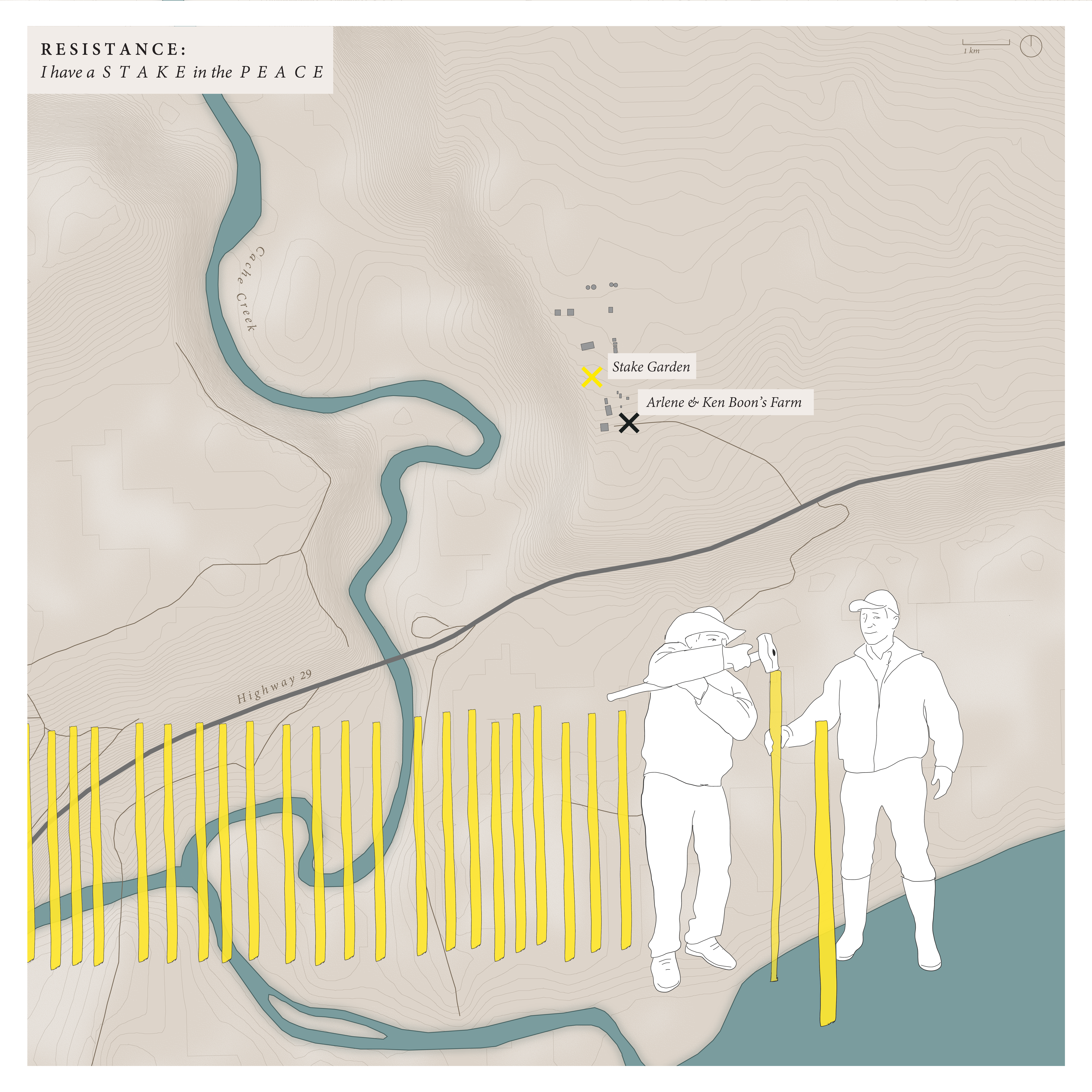
Resistance II: I Have a Stake
in the Peace
The ‘I have a stake in the Peace’ campaign began as BC Hydro expropriated and began preparatory work on Arlene and Ken Boon’s farm in the Peace Valley. The Boons are leaders in the protest against Site C, and suspected that BC Hydro was retaliating by proceeding with work on their farm ahead of schedule. Their home was soon full of heavy machinery and survey stakes. Friends of the Boons transformed the act of pounding a stake into the ground into a fundraiser and assertion of claim. For $100 supporters could purchase a stake, inscribe it with a message, and have it pounded into the Boos’ property. Proceeds went to support the legal costs of lawsuits. A garden of hundreds of yellow stakes grew up over three years; the rejection in 2019 of West Moberly and Prophet River First Nations’ application for a stop-work injunction put the campaign on hold.
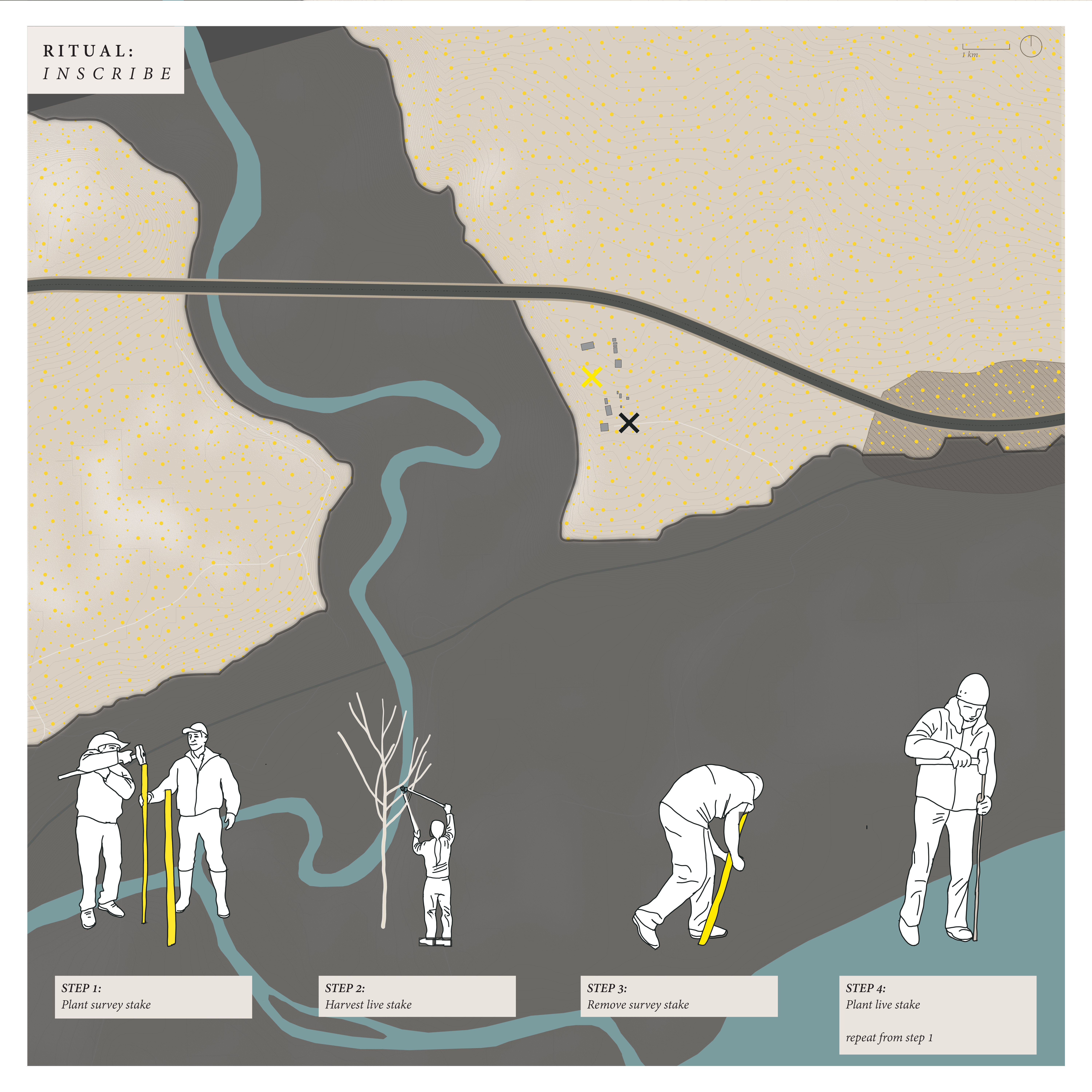
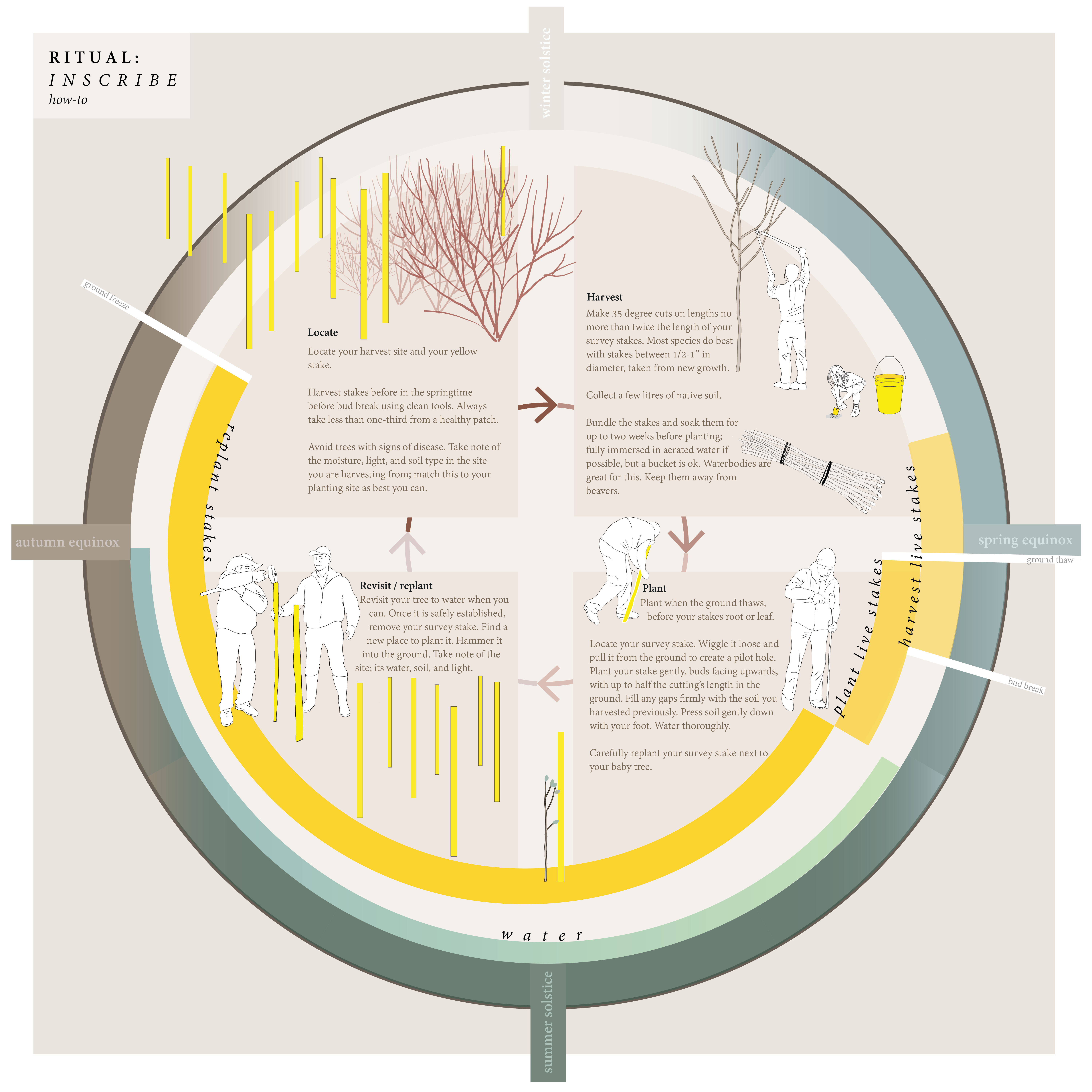
Ritual II: Inscribe
Memory scholar Claire Colebrook describes the Earth as an archive, and the Anthropocene as inscription that compromises the Earth’s ability to hold memory. Site C is an inscription that erases, literally and symbolically, memory from the landscape. Inscribe is a constructive ritual of mark-making, beginning where ‘Stake in the Peace’ leaves off. This ritual reasserts agency and continued care for the land, leaving an inscription for successive generations. Mourners continue to write messages on stakes and plant them in the ground. Later, they harvest living stakes from appropriate tree species, return to their survey stake, uproot it, and plant their living stake in the pilot hole. The cycle begins again as a new site is selected and the survey stake is replanted.

There are six species of tree and shrub native to the valley that can be planted via live-staking. This process should happen in early spring, and can be solitary or collective.
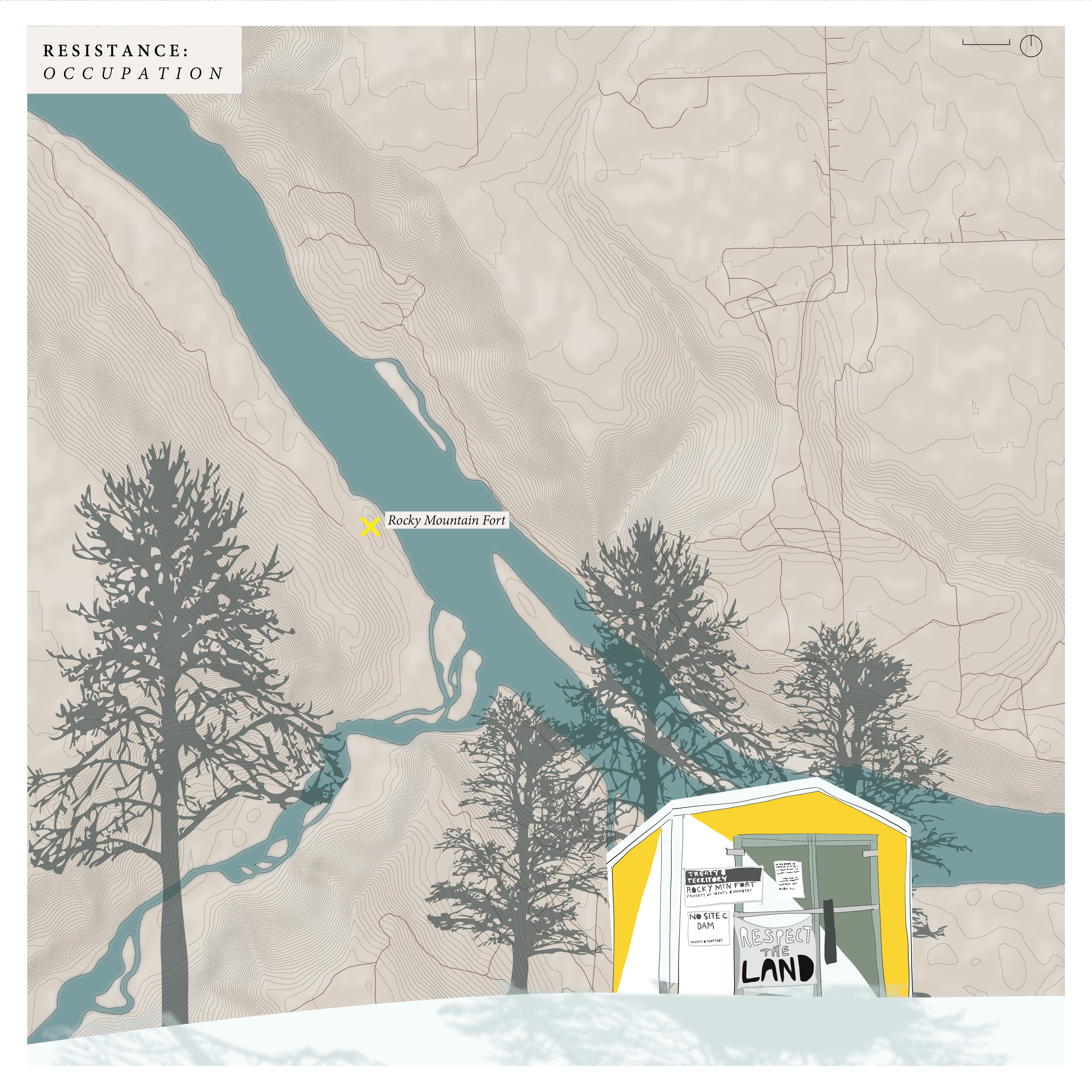
Resistance III: Occupation of Rocky Mountain Fort
Rocky Mountain Fort was chosen as a permanent base in 1793 by Alexander Mackenzie on his first excursion west of the Rockies. The fort eventually housed voyageurs of the North West Company and later Hudson’s Bay. These voyageurs developed trade relationships with surrounding Indigenous nations. This north-facing terrace above the Peace River held not only the fort but numerous lodges. Until recently, old growth cottonwoods predating Mackenzie’s arrival lined the shore. The site was never comprehensively studied or surveyed, and the Indigenous history of the site was particularly overlooked.
On New Years’ Day, 2016, after weeks of preparation, a number of Site C protestors began their occupation of the site to prevent BC Hydro from logging the island. On March 1st, BC Hydro issued a lawsuit against several participants and the occupation ended. The island was logged and a retention berm holding acid-generating rock waste was constructed over top. This place on the landscape has been effectively erased and the stories it held dislocated.
Ritual III: Locate
When landscapes are destroyed, memories, stories, and practices are dislocated. An elder from Kwadacha First Nation, commenting on the impact of the WAC Bennett dam on their homeland, described the disturbing feeling of remembering events and places but being unable to locate them on the physical landscape. Rocky Mountain Fort has been all but erased; the stories and memories carried by the living have been uprooted.
Locate offers a simple strategy to pinpoint the place that was, relocating memory in the new landscape. The site for this intervention is known as Protestor’s Point, an overlook is property owned by Site C resistors. It is one of the only places citizens can access an unobstructed view of Site C.
Locate makes use of remnant stone from blast-excavation, used in the construction of Site C. A byproduct of this kind of excavation are rock fragments bearing the marks of drilled explosives channels. The rock fragment is positioned at Protestor’s Point, with its channel functioning as a sight, pointing the viewer’s eye directly at the location of Rocky Mountain Fort.
The distance is about a kilometre, at an angle of about 10 degrees. Once the reservoir is filled, the sight will point to the inscrutable surface of the water.
The ritual that accompanies this intervention is the sharing of memory. How will people communicate about what happened in the Valley to people who weren’t there? This intervention, like the others, doesn’t tell the story on its own, but supports the transmission of memory into the future.